| |
Welcome to the | |
| |
AACES-2 Project | |
| Australian Airborne Cal/val Experiment for SMOS |
|
Home page
Google Earth (KML file) Workplan SMOS AMSR-E WindSat ASCAT PALSAR ASAR MODIS MTSAT-1R ASTER Landsat CHRIS AVNIR-2 PLMR data Thermal Infrared data Multi-Spectral data Monitoring stations Soil moisture sampling Vegetation sampling Campaign shapefiles DEM Land use Climate data Soil classification Soil water capacity Soil texture analysis AACES homepage Moisturemap homepage |
The Advanced SCATterometer (ASCAT)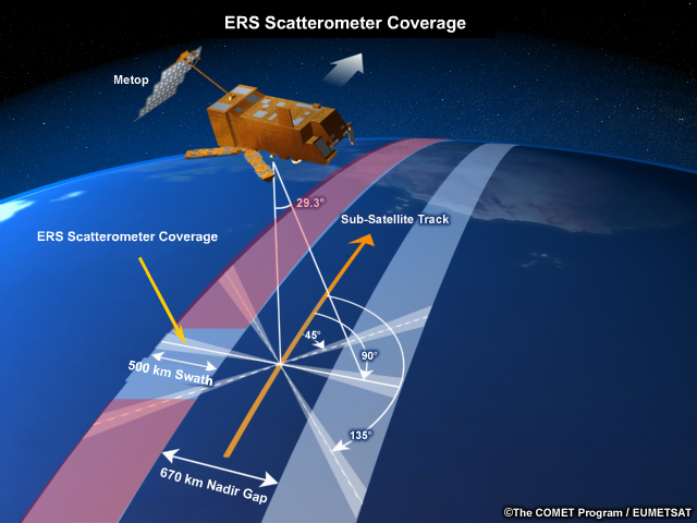 Source: http://www.meted.ucar.edu, accessed on 28th, Apr. 2010
The ASCAT, operating at C-band, provides continuity to the ERS-1 and ERS-2 scatterometers. The ASCAT is onboard the Metop-A satellite, which was launched into a sun-synchronous orbit on 19 October 2006 and has been operational since May 2007. ASCAT operates at a frequency of 5.255GHz in vertical polarisation. Its use of six antennas allows the simultaneous coverage of two swaths on either side of the satellite ground track, allowing for much greater coverage then its predecessors. It takes about 2 days to map the entire globe. A 50 km resolution soil moisture product is now operational from ASCAT, available from EUMETSAT.
ASCAT overpass timeASCAT coverage for the Murrumbidgee Catchment during the AACES-2 campaign has been calculated by a Fortran program based on NORAD data for 29th, Aug. 2010, and is summarized in the table below. Date and time are in UTC. Aircraft flights were assumed to be conducted at 7:45 for descending overpass and 20:35 for ascending overpass.
|
||||||||||||||||||||||||||||||||||||||||||||||||||||||||||||||||||||||||||||||||||||||||||||||||||||||||||||||||||||||||||||||||||||||||||||||||||||||||||||||||||||||||||||||||||||||||||||||||||||||||||||||||||||||||||||||||||||||||||||||||||||||||||||||||||||||||||||||||||||||||||||||||||||||||||||||||||||||||||||||||||||||||||||||||||||||||||||||||||||||||||||||||||||||||||||||||||||||||||||||||||||||||||||||||||||||||||||||||||||||||||||||||||||||||||||||||||||||||||||||||||||||||||||||||||||||||||||||||||||||||||||||||||||||||||||||||||||||||||||||||
|
Created: September 2010 Last Modified: September 2010 Maintainer: YE Nan, Ye.Nan@monash.edu |